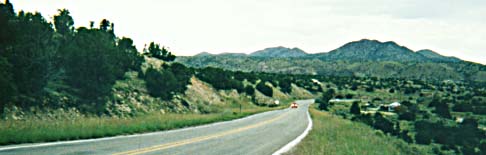
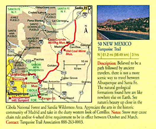
--The Turquoise Trail--
On the reconstruction of the National Scenic Byway
---------
Portions of the Byway lost in 2002! -- Examples of what we need to avoid in the future!
Letter
from CAC
P.O. Box 172
Cerrillos, NM 87010
December 7, 2001
[To] Mr. Ted
Garcia
Project Design Engineer
New Mexico State Highway and Transportation Department
1120 Cerrillos Road
Santa Fe, NM 87505
Dear Mr. Garcia:
The members of the CAC thank the New Mexico Highway and Transportation Department and its design consultants for their continuing efforts on the plans for the Turquoise Trail. While much progress has been made, the current plans remain inappropriate for a National Scenic Byway.
The most current and comprehensive study of lane widths on roads like Highway 14 indicates that 11' lanes generally are safer than 12' lanes (Noland, 2001); the study includes both curved and straight road segments. The Department has furnished the CAC with a number of documents purporting to show that in curves such as between Madrid and Cerrillos, 12' lanes are safer than 11' lanes. Recent literature suggests that the statistical model underlying these studies is invalid, because accidents are not normally-distributed events (Miaou and Lum, 1993). (The Department and its consultants have been furnished with copies of both documents.) But even if the Department's studies are taken at face value, they indicate that 11' lanes with 5' shoulders (the CAC compromise) would provide precisely the same safety improvement as 12' lanes with 4' shoulders (the Department's plan) [Zeeger, et al., 1992, Table 3, p. 17]. However, 11' lanes, coupled with the colored shoulders agreed to, would reduce the perceived width of the roadway, and reduce the speeds of cars, which comprise more than 90% of the traffic on the road. (The Department rationale for 12' lanes in the curves is "off-tracking" by large commercial vehicles such as trucks and buses. The Department cannot provide even a single instance of an accident attributable to off-tracking on the existing narrow road.) These members of the CAC would appreciate a clear explanation of why 11' lanes and 5' shoulders are unacceptable.
The proposed cross-section for the road includes 2 feet of asphalt and an asphalt curb behind the guardrails [ERRATA: rather than 2 feet of additional asphalt, it would total 3.6 feet]. This space may be required to allow the guardrail to function, but we believe that paving it is quite destructive to the scenic qualities of the road. The CAC has proposed a functional alternative to the asphalt curb to control road runoff on the downhill side of the road before it gets behind the guardrail. Even if the Department rejects that alternative, we suggest that established vegetation behind the guardrail would control any potential erosion. There may be a slight increase in construction cost to establish vegetation in this area, but it is likely to be offset by reduced maintenance costs. We believe that a life-cycle cost analysis should be done. Even if establishing and maintaining vegetation is slightly more expensive, we believe that the benefits in tourist dollars of maintaining the scenic quality of the road will outweigh the costs. We would appreciate a clear demonstration to the contrary.
We remain concerned with the plans for the San Marcos arroyo bridge. The Department's design team had developed an alternative that replaced one lane of the bridge at a time. That alternative was complicated by the soil characteristics discovered by geotechnical drilling conducted after its development. But we understand that the ultimate reasons for its rejection were "constructability" and the safety of a one-lane temporary road at night. While eventually vegetation will return to the very bottom of the arroyo, we are concerned with the revegetation of the approaches to the two-lane temporary bridge that the current plans require. Given that the current schedule is for construction in 2006, we suggest that work on the plans for the bridge be suspended until the Department has thoroughly investigated the alternatives for traffic control at night on one-lane roads. The safest of these alternatives probably is expensive. But this is a special road, recognized as such by the New Mexico State Legislature. Special things generally cost more.
We believe that excessive reliance on rip-rap for erosion control is detrimental to the scenic qualities of the road and that other protective alternatives exist. We request their detailed investigation. When rip-rap cannot be avoided, we suggest that stone which will blend with the existing landscape be used, along with measures that accelerate the establishment of vegetation in the treated areas.
We believe that the signage included in the current plans will have a negative visual impact, that much of the signage is unnecessary, and that much of it is out of scale with the road. We believe that at least one more turnout is desirable, to allow tourists to get over and allow locals in a hurry to pass. The nominal cost of the turnout will be repaid if a single fatal accident is avoided.
We believe that serious consideration should be given to the use of recycled glass in at least the base course of the new road. Specifications for the use of the material would have to be developed, but that is a one-time cost that could be spread over many highway projects in the future. The material will likely cost more compared to the mined alternative, if only the direct cost to the Department is considered. We would appreciate an analysis of the total costs, including the avoided costs of placing glass in landfills and the costs to surrounding communities from mining. If the timeframe for the first part of the project does not allow for completion of these items, they certainly can be accomplished before the second increment of the project.
Given the changes in budget and schedule the CAC has seen in the past and the vagaries of memory, we believe it would be appropriate for the Department to formalize commitments made in the process that the CAC and the Department have gone through since the Environmental Assessment for the project was written. Besides responses to the items listed above, we believe that the following additional commitments should be part of the record:
1) Complete re-vegetation of all disturbed areas will be accomplished in each phase of the project. There will be no "running out of money" or deferral of re-vegetation to future phases of the project.
2) Areas where re-vegetation is unsuccessful in the first phase of the project will be included for re-vegetation in subsequent phases, after determining why the first-phase efforts were not successful.
3) Shoulders will be constructed and maintained with a different-colored material from the driving lanes, and the shoulder material will blend with the existing landscape.
4) The road tapers will be constructed and maintained with a covering of "duff" (local soil) to encourage the growth of vegetation, slow run-off, and reduce visual impacts.
5) The clear zone requirements of AASHTO will be applied only to areas of re-alignment of the roadway. The Department, its contractors, and the CAC will work together to preserve existing vegetation elsewhere in the Project.
6) There will be monetary penalties to the contractors for "out of bounds" disturbance.
7) The Department will work with the community and the Turquoise Trail Association to develop a maintenance plan for Highway 14 appropriate to a scenic byway, and will adhere to the maintenance plan.
The Department repeatedly has agreed verbally to 1) and 3), and we wish to formalize this agreement. We also believe that the Department should agree to the others.
Please include this letter in the environmental re-evaluation of the project that we understand is underway. Thank you for your consideration.
Tom Allen
Helen Boyce
Richard Crombie
Chris Hodge
Diana Johnson
Ross Lockridge
Linda Murnik
Tom Parker
Kim Sorvig
CC: Rochelle Byars, Parsons Brinckerhoff
--From, America's Byways, All-American Roads & Scenic Byways, FHWA Comments on "99%" Final Design by consultant, Donal Simpson
To: Ted Garcia, NMSHTD, Chris Baca, Parsons-Brinckerhoff
Date: January 4, 2002
From: Donal Simpson [AIA, AICP, ASLA]
Subject: NM 14 PS&E Submittal
The following are my comments on the PS&E Submittal:
Retaining walls: No retaining walls are shown on the PS&E submittal, although there are still "retaining wall" notes on the plan and profile drawings in some locations. My understanding is that the soil conditions will support 1.5 to 1 slopes, and that retaining walls will not be necessary. This is excellent.
Concrete wall barriers: Concrete wall barriers are indicated in some stretches of the road between Madrid and Cerrillos. These have not been previously discussed or presented to the Community Advisory Committee for review. These appear to enable the elimination of retaining walls, which is good. I am concerned about the aesthetics of the barriers, however. Similar treatments can be seen on US 84 at the interchange with NM 502 in Pojoaque, and just south of that interchange for a mile or two. I would recommend that CAC members visit this location to see for themselves what the barriers look like. One possible treatment to blend the barriers more compatibly with the natural slope might be the use of form liners to create a faux-stone appearance on the surface of the barriers. My understanding is that the Texas Transportation Institute has crash-tested and approved barriers with textured surface treatments. Examples of this treatment can be seen at the new Rental Car Center at the Albuquerque Airport, and at the I-40 interchange with (I believe) Central Avenue in Albuquerque. Again, I would recommend that CAC members visit these locations to see the effect of the treatments. This is the treatment that is indicated for the bridge rails, so it would provide a consistent aesthetic treatment throughout the project. While it can look artificial if not handled expertly, my opinion is that it would look far more appropriate in this environment than a smooth concrete surface with a colored stucco-like treatment.
Guardrail installation: The guardrails for the project are still shown to be installed with an additional 3.6 feet of pavement beneath and behind the guardrail. The CAC has objected to this installation since it first appeared on the drawings at the 65% submittal phase, but the Department has been obstinate in their refusal to propose other installation methods. In my opinion, this installation method is completely inappropriate for a National Scenic Byway, and is contradictory to the spirit of the project, of a Scenic Byway, and of the State Legislature Memorial encouraging the NMSHTD to exercise "special care and sensitivity" in the planning and design of NM 14. This installation method adds additional fill, additional cost, and excessive ugliness to the project, especially since there are nearly 2 miles of guardrail in the 4 mile stretch of road between Madrid and Cerrillos. In my opinion, it will be an embarrassment to the State if the road is built this way. [emphasis added]
San Marcos Arroyo Bridge: There is still a temporary bypass shown, to the west of the existing bridge. While the CAC has continuously raised concerns about the damage this would do to the natural landform and vegetation in the arroyo, my understanding is that geotechnical conditions under the approaches to the new bridge make it impractical to build the proposed bridge on the existing alignment without a temporary bypass. The PS&E submittal does include a note on the landscape drawings to the effect that the natural grade will be replaced to match existing after completion of the bridge construction. This direction to the contractor needs to appear throughout the documents, not just on one landscape drawing. It is unlikely that the item will be adequately covered in the bid, and that the general contractor and landscape contractor will wind up disagreeing about who has responsibility for the restoration of the terrain, to the effect that it will not get done. To avoid this, it must be clear that the grade restoration, to its natural state, is included in the project. The re-vegetation plans are good. However, there still appears to be no provision in the plans for watering the plant material during the time it takes for them to become established. Without proper provision for water, the landscape plans will be ineffective and the plant material will all die. Watering during the plant establishment period, as well as a landscape contractor warranty on all plant material during the establishment period, is standard practice in the industry and must be included as part of the NM 14 contract.
Gabions: ["rip-rap"] There is a very extensive gabion installation shown in the arroyo at Rogersville Road, that never appeared on any previous plans and has never been discussed with the CAC. My understanding is that the Department had been working on these plans for some time with a property owner to mitigate erosion on her property, and asked PB to add the design to their plans shortly before this submittal was completed. Gabions are also shown in other locations for erosion control. There are two issues here. The first is that treatments at Rogersville Road had been discussed in previous CAC meetings, and the Department never indicated that they were working separately on a design. This is disrespectful of the CAC at best, and deceptive at worst. The second issue is that the use of gabions for streambank erosion control is a dated practice that has generally been replaced with more natural treatments. Suggestions for these treatments have previously been provided by the CAC, but seem to have been disregarded. The gabion treatment at Rogersville Road is very visible from NM 14, and is an artificial intrusion into the natural environment that is inappropriate for a National Scenic Byway. Treatments at the Galisteo River are also visible from the roadway. The design of the erosion control methods should be revisited to develop a method that is more in keeping with the visual quality of the natural environment. The proposed designs should be reviewed with the CAC as well, before the plans are considered complete.
Signage: The signage plans indicate what appears to be an unnecessarily excessive number of signs. The CAC has provided a detailed commentary on the signage, suggesting ways to reduce the numbers of signs, eliminate redundant signs, and combine signs in order to reduce the visual clutter that would result from the current plan. It appears that the CAC comments can be achieved while still complying with MUTCD requirements. The signage plans should be reviewed to take these comments into consideration and reduce the number of signs on the project. [We were promised that this would be addressed. --rl]
12 ft. lane widths in the Madrid Curves:
The issue of lane width through the
so-called Madrid curves is a complex one, in which both sides
are concerned about safety. The Department has presented technical
information to support their desire for 12 foot wide lanes, and
the CAC has rejected this information because they do not believe
that it in fact supports the need for 12 foot wide lanes. [www.raintreecounty.com/savingRd.html]
The key issue that the Department and PB have presented is the
concern for off-tracking by large trucks and busses. The CAC's
concern is that the wider lanes will encourage higher speeds
through the curves, and will be more dangerous than the truck
off-tracking might be. Both sides seem to have become locked
into their positions. I suggest a couple of steps that might
be taken to help resolve the issue:
Bring some truck drivers that actually
use the road into the discussion, and see what they think about
their ability to safely negotiate the curves with 11 foot lanes
and 4 foot shoulders. The Department could even arrange to have
Department and CAC representatives ride in a truck with a driver
to see first hand if off-tracking really would be a problem or
if the drivers can safely negotiate the curves with the extra
pavement provided by the shoulders.
Have CAC and Department representatives
tour NM 503 between Nambe and Chimayo, which has 12 foot lanes
and 6 foot colored shoulders, to see if there really is a sense
that higher speeds are encouraged by the lane and roadway widths.