## Portions of the Turquoise Trail--Lost! ##
--Examples of
wide, inappropriate arterial
design upon scenic
rural collectors--
Plus--An introduction to "Context Sensitive Design"
(CSD)
--Link to examples
of more appropriate
designs under development--
--Asphalt fails as erosion
control, whereas vegetation along
scenic roads is in context --
~
Images "before and after"
road widening for subdivision
turnouts
Beautiful, intimate sections
of the National Scenic Byway, the Turquoise Trail (NM 14) have
lately been lost to overbuilt turnouts constructed for
new subdivisions. Although new turnouts may be needed, in the
Turquoise Trail instance, an asphalt band that reaches nearly
90 feet wide and half a mile long has been built for the Campbell
Corporation's San Pedro Overlook. This new turnout extends pavement
that was only about 24 feet wide and significantly changes the
character of this section of the National Scenic Byway. Additionally,
similar wide turnouts are being built for Roger Cox & Associates'
"Paa-Ko" development, which
also is on the Turquoise Trail.
--Turnouts, before and after--
Campbell Corporation's "San Pedro
Overlook", View South (Left
image "Before"-- Right image "After")

Campbell Corporation's "San Pedro
Overlook", View North (images "Before & After")
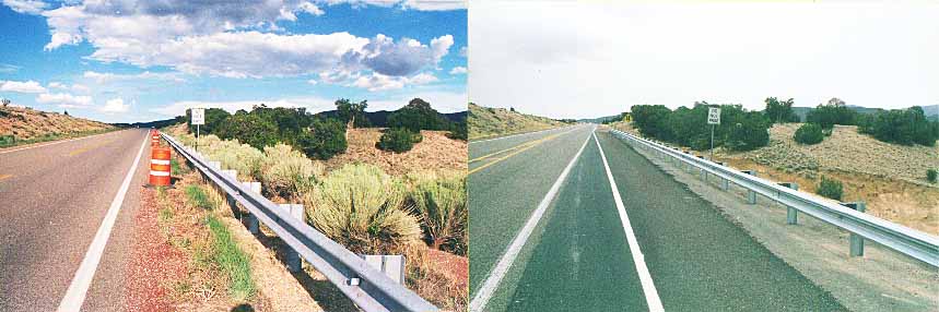 Photos, © 2002, 2003 by Ross Lockridge
Are
arterial width maximized constant flow designs appropriate or
even safe on "rural collector" roads such as the
Turquoise Trail? New
research suggests not. Yet sadly, the over-reaching development
on the Scenic Byway goes on. By December of 2002, as if trying
to catch up with the Overlook's arterial design dimensions, similar
dimensions were under preparation for pavement now spread along
an entrance to the Roger Cox & Associates "Paa-Ko"
developments. Next image has San Pedro Overlook dimensions
listed:
San Pedro Overlook
is Overdone
A National Scenic
Byway is replaced by a NM State "maintenance" highway
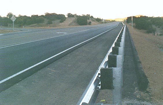
San Pedro Overlook
pullout completed--View: Northbound--Photo, November 3, 2002
Dimensions of the Overlook constructed entry
--Paved width is approximately
88 feet.
--Total width to bottom of ditches (NOT counting the up-slope
cuts) is approximately 104 feet.
--Length of the Turquoise Trail this turn-out occupies is 4/10th
of a mile, to just under half a mile.
Dimensions of components -- Cross section dimensions just
south of the entry, from the left to the right side (or guardrail
side & point of photo):
Left
to right: Ditch slope 7'; paved shoulder 7'7"; turn-out
lane from Overlook southbound 10'8"; southbound lane 11'6";
center strips 1'6"; turn-in lane northbound 11'; north bound
lane 12' 5"; paved shoulder to front edge of guardrail 8';
pavement under guardrail from front to curb 3'; width of curb
7"; ditch slope 8 to 9'.
An excerpt from:
"Designing Roads with Communities--Context Sensitive Design
for Highways"
Produced
by the Surface Transportation Policy Project (STPP
New Mexico) with the Cultural Landscapes/Flexible Highway
Standards Team of the NM Transportation Initiative
Joanne McEntire, AICP, October
2002
When building or improving
highways, Context Sensitive Design (CSD) is "an approach
that places preservation of historic, scenic, natural environment,
and other community values on an equal basis with mobility, safety
and economics," according to Federal Highway Administrator
Mary Peters. Attention is paid to the places that a highway
goes through by putting greater emphasis on the needs and values
of the community during all phases of the project. A process
that involves the community is likely to lead to a better road
project because it reflects the context, or environment, in which
it is located.
Context Sensitive Design has become a normal
mode of operation in a few state Departments of Transportation
(DOT). In 1999, the Federal Highway Works Administration (FHWA)
supported a pilot project to define and practice CSD with five
states: Connecticut, Kentucky, Maryland,
Minnesota, and Utah. Research indicates that the states trained
their staff, consultants, stakeholders, local government workers
and other related groups on utilizing a flexible approach towards
the design of highway projects within three a year period. This
effort has led to a movement called "Thinking
Beyond the Pavement."
Sensitivity toward place-and the people
within a place-became acceptable following the adoption of ISTEA
(the Intermodal Surface Transportation Equity Act) and the National
Highway System Designation Act, along with US Code, Title 23,
109 Standards. The federal government recognized that the surrounding
environment and community aspects could be taken into account
in new construction and reconstruction, resurfacing, restoration
or rehabilitation of highways. In addition, access to other modes
of transportation was acknowledged as a factor that could be
considered. Vastly improved projects could be attained by enhancing
the process; communication with the general public is "open,
early, and continuous" (see Thinking Beyond the Pavement
box).
The environmental context of a highway may
be a congested urban district, a rural town, or an open landscape
of farms, ranches or forest lands. A highway project may involve
local governments as well as the DOT's local district. Wherever
it is located, flexibility in the project's design can be utilized,
and local communities and stakeholders should have opportunities
to participate in the entire process.
~
Context Sensitive Design for the Turquoise Trail?
For
the Turquoise Trail, reconstruction
designs are under development that, if
successful, might help set a good precedent for other NM rural
collectors. Prior to the Paa-Ko and Overlook developments, citizens
along northern stretches of the Byway in Madrid, Los Cerrillos
and San Marcos area have, with limited success, been pressing
the New Mexico Department of Transportation to take context --
the neighborhood communities, the glorious beauty of this intimate
road, and the calming effects of the immediate vegetated landscape
on drivers' minds -- into consideration whenever the road is
repaired or rebuilt. See
details: NM 14 CAC / NMSHTD (Draft)
'Record of Agreement' (April 24, 2002). See update:
New as of Dec. 2003: Proposed
Dimensions.
~
--Asphalt failure--
On rural and scenic roads, the NM transportation department should commit to
using vegetation rather than asphalt for roadside erosion
control including areas of guardrail as well as tapers. In the
above image, the curb behind the rail will hinder the return
of needed vegetation. Besides, as shown below, asphalt is
not maintenance free. To: consultant, Donal Simpson, on this
inappropriate method
of guardrail installation.
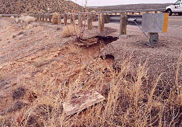 Photo, NM 285 at El Dorado, March
8, 2002
Photo, NM 285 at El Dorado, March
8, 2002
Plant
life, rather than asphalt, is the better and more appropriate alternative for
the prevention of erosion on scenic and rural roads. Vegetation,
once established, can be the more permanent solution to this
problem even in arid climates. To aid in getting vegetation established,
the use of "cellular-containment fabric" is a proven
method. It is a filter-fabric forming small vertical chambers
or cells for soil retention. Even through dry periods, the soil,
with the aid of the fabric, is held in place, giving the vegetation
the time needed to take root. Once plant life (usually selected
native grass and flower seed) takes hold, unlike asphalt, plants
do not eventually crack, and add to the problem of erosion with
petroleum based polluting debris. (To: more
context in-sensitive examples in New Mexico)
To: "Portions of the Turquoise Trail--LOST",
an article,
1000 Friends,
click "Publications", Nuestro Pueblo's Spring
2003 issue, p 12.
To: Paa-Ko goes arterial!
To: Other
NM Context In-sensitive examples
To:
To: The Turquoise Trail Page
To: Billy the Kid Trail (U.S.
70)--threatened NM National Scenic Byway
To: Resources for Saving America's
Rural Roads and Communities--a listing