"The applicant has clearly mined outside the [once permitted] 3 acre area ... without ... County approval, and the applicant has not provided reclamation of any kind." --From, Santa Fe County Land Use Administrator to CGP, July 6, 1999.
July 2005 news!
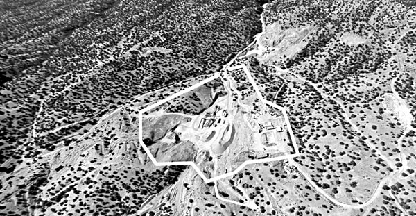
Unsuitable Siting: Narrow roads from previous exploratory drilling activities by Occidental Minerals in the 1970s (gray areas) that some county officials deemed significant, do not justify or excuse the poor siting problems encountered here for strip & crush gravel mining (white central area). Its neighbors include the village of Los Cerrillos, the Rancho Alegre subdivision, numerous individual residences, and the Turquoise Trail National Scenic Byway, and it is directly adjacent to the 1100-acre Cerrillos Hills Historic Park. It is, however, significant to remember that the (then named) NM Environmental Improvement Agency denied "Oxy" permission to mine and that the people of the area were, as with CGP, likewise overwhelmingly opposed to that operation. Documents: The Cerrillos Hills, 1974 to 1978, A Battle For the Land & Water, Simmons / Lockridge, 1990.
In 1993 "Cerrillos Sand and Gravel" (who then more fit a description of a "small" gravel yard) became Cerrillos Gravel Products in association with Richard Cook of Associated Asphalt, a very big time operator. Associated moved in a crusher and the original 3 acre zoned gravel "sifting" operation became over night a heavy hard rock industrial operation that in a few short years stripped considerable acreage beyond the permitted zone.
The Santa Fe Board of County Commissioners has shut down ("suspended") CGP for its egregious excesses, requiring, among other things, the reclamation of the over-mined area. The local people are overwhelmingly opposed to ever reopening this poorly sited incompatible industrial mine.
CONCERNING RECLAMATION, it is significant that the decades old Oxy exploration left many trees & bushes thriving. Note: "[N]othing in the Applicant's [CGP's] submittals demonstrates it can successfully establish trees at this site." --F. L. Green------------------ --photos to aid in the reclamation effort--
Site Contents:
--Santa Fe County suspended the gravel pit's permit 26 Jan. 2000. The Memorandum of Understanding (MOU) & Reclamation conditions.
--The gravel mine near to historic & prehistoric mine sites (195 k).--CGP owner: Brad Aitken of Houston, TX; operator: has been Richard Cook, of Associated Asphalt, Espanola, NM.
Advice on Reclamation at the CGP Sites, from Environmental Engineer, F. L. Green
Aerial 1993, NM Abandoned Mine Land Bureau, 1993
Satellite 1996, NASA, Oct. 6, 1996
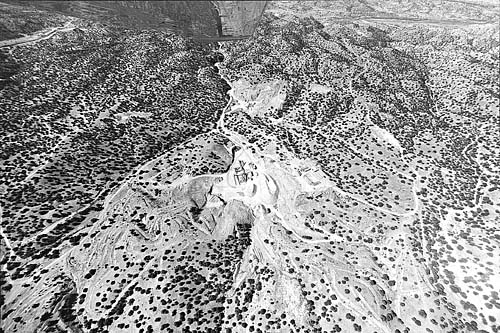
Aerials 1997 (uncropped image below) ID: cgp aerial 1997 frame 2-11 (w/ 3 closeups)
To close-up, Oxy exploratory roads from the 1970s, (image: 1997)
To close-up, SW, 1997
To close-up of pit area, 1997
Two other views, 1997
Aerials 1998
To aerials 1998, 1 & 2
To aerials 1998 3 & 4
To aerials 1998 5&6
Aerial 1999
To aerial 1999 & close-up
Aerials 2000
Becho CGP Aerial Closeups
Aerials of "Becho" Area, 1993-9Oxymin 1978 (approx.), the eariliest photo thus far.
Aerial as Oxymin left the land, approx. 1978For more information Email the Rural Conservation Alliance, P.O. Box 361, Cerrillos, NM 87010 ------------------ Looking south File: 2-11cg97.jpg: 30 April 1997
Concerning reclamation, it is significant that the decades old exploration left many trees & bushes thriving. Note: "[N]othing in the Applicant's submittals demonstrates it can successfully establish trees at this site." --F. L. Green